The best of both worlds
Patchworks™ is a strategic long-term planning model that works with detailed operational data, and it does both at the same time. These two planning paradigms are integrated from the start, so you don't have to put them together at the end. This keeps your results consistent and saves you time.
Spatial and road modeling objectives are integrated into the core of Patchworks, making it easy to explore and evaluate long-term spatially compliant plans. Forest stand polygons are the fundamental decision unit and this makes the model incredibly transparent. The results provide the elements of an operational plan, showing where the harvest occurs, what silviculture is applied, what roads are used, and how the forest grows for every polygon and every planning period. The plan is explicit, and the long-term and short-term aspects demonstrably support each other.
The Patchworks user interface is visual and intuitive. The best way to understand the Patchworks advantage is to see it in action. Contact us today to schedule an online demo.
Strategic Vision
- Patchworks lets you model production targets and landscape-level goals over multiple rotations to ensure long-term sustainability.
- Patchworks solves for multiple simultaneous goals, including spatial targets, using a flexible goal-programming formulation.
Operational Focus
- Location is important, and Patchworks has spatial operators that help you include your operational realities within the strategic plan.
- Include operational planners upfront during the management planning process to ensure viable and cost-effective on-the-ground management.
Efficient Collaboration
- Strategic and operational planners can work together to refine short-term operations and balance long-term goals, all within one integrated framework.
- Use the spatially explicit outputs from Patchworks to demonstrate compliance with sustainability goals.
- Efficiently address certification requirements.
Patchworks is loaded with features
And they all come included with the base package, so there are no expensive add-ons to purchase. When you are ready to extend your analysis, all the tools are at your fingertips.
Flexible Spatial Targets
Implement your spatial pattern policies naturally with our comprehensive suite of spatial objectives. Vary multiple pattern objectives over time and across the landscape to suit your needs.
Learn more...Road Network Modeling
Road modeling is built into the core, not an add-on. Match your operational reality with an economically rational formulation that is intuitive, easy to understand, and easy to visualize.
Learn more...Product to Mill Allocation
Optimize the allocation of harvested volumes from stump to mills using the multiple-product to multiple-destination formulation.
Learn more...Point-and-Click or Scripting
Start your prototyping with the easy-to-follow wizards and a point-and-click interface, and move into reliable, repeatable production with automatically generated scripts.
Learn more...Comprehensive Reports
Distill the wealth of modeling data into your custom set of reports using your headings and labels. Choose from a rich set of easy-to-use templates.
Learn more...Many Supporting Tools
The Patchworks system provides an ever growing toolkit to prepare models, conduct analysis, and render informative results. Have a look at what is available.
Learn more...Choose your deployment style
Every organization is different, and it is important to be able to deploy Patchworks™ in the way that best fits your workflow and budget. Our licensing and activation options make it easy to choose a combination that is right for you.
On the desktop
Use Patchworks on your premises on your own hardware, under your control, and close to your datasets.
Dongle
Enable your software with a hardware key for complete control and no dependency on the internet. Perfect for long-term stable installations and for road warriors.
In the cloud
Use Patchworks on EC2 or Azure to obtain the flexibility and scalability of the cloud.
Networked
Enable your software over the internet from our highly reliabile license server. Networked licenses may be node-locked or floating, depending on your requirements.

Choose your licensing style
Perpetual license
Perpetual licenses allow you to "pay once, use forever". This arrangement provides the best value for long-term cost savings. Combine this with a support plan to keep your software up to date with the latest features and enhancements.
Subscription
Choose a Patchworks subscription to license the software by the month. This option provides the ability to scale your capacity up and down as your needs require.
Outsource
Want the benefits of spatial modeling but would like someone else to handle the technical details? Let us put you in touch with highly qualified analysts who can handle your workload.
Schedule an online demonstration
The best way to quickly understand the Patchworks™ advantage is to participate in a brief online demonstration. The interactive demo can be tailored to suit your interests and takes about one hour. The tour will use the Patchworks™ model to look at a real planning problem and will present the concepts that make Patchworks so effective.
Contact us to schedule a convenient time.
Try Patchworks™ out for yourself
Would you like to roll up your sleeves and try Patchworks™ out yourself? Our evaluation program provides the complete modeling software, comprehensive documentation, and a sample dataset. Work through the sample dataset tutorials or build a model using your own datasets.
Contact us to obtain an evaluation license.
Let us build your model
Want to get up and running quickly? Let Spatial Planning System build a model to your specifications and turn the keys over to you. We can rapidly build your custom model so that you don't waste time, and then provide the training you need to get up to speed.
Contact us to discuss a project.
What Clients Say

Cal Dakin, R.P.F., MBA
Woodlands Manager
Al-Pac Forest Industries
"For the past 18 years Al-Pac has relied on Patchworks for timber supply analysis to meet our stringent ecosystem management planning requirements, the regulatory requirements with the Government of Alberta, and, equally important, to reduce our planning and delivered wood costs and supply risks. In addition, we have used Patchworks as an essential tool in our role as land stewards to explore landscape scenarios in response to the continual and ongoing shifts in environmental policies. Al-Pac considers the Patchworks planning model second to none in supplying all of our specialized mapping and spatial planning needs."

Dan Rouillard, R.P.F.
Senior Analyst
Forsite Consultants Ltd
"The quintessential 'Swiss Army knife' of forest management models. Patchworks enables us to provide our clients with comprehensive spatial modeling solutions that facilitate a participatory and interactive planning process that spans the analytical spectrum from strategic to operational planning. Definitely our tool of choice for an ever-growing and wide range of analysis and modeling scenarios."

Bob Christian, R.P.F.
Partner and Senior Analyst
FORCORP
"FORCORP has been using Patchworks for two decades on a wide variety of projects for numerous industry, government, and NGO clients. Patchworks has proven to be flexible and robust in effectively addressing the spatial planning problems that are the forefront of forestry and resource management and has helped to give us a competitive edge in our sector. Spatial Planning Systems has been responsive to our needs and has continued to enhance the platform as new challenges arise, thus furthering the versatility of the software."
Latest News
Updates and tips for Patchworks users
Training
Self-paced training
Online self-paced training is available for the Patchworks modeling system. The training modules are included in the online documentation and are available to all Patchworks users. This self-paced training has had a recently been revamped to expand the material, provide better step-by-step illustrations, and highlight new features. This article describes the training that is available and what it covers.
Read More
Training
Sample data for the Quick Tour self-paced learning module
The C5 sample dataset is based on a portion of the Crowsnest Pass forest in western Alberta. The Patchworks sample model, which is derived from this dataset, incorporates a range of Patchworks features and serves as an excellent resource for demonstrations and learning. The self-paced learning sections in the Patchworks User Guide are based on this dataset. This article provides a link to download the version of this dataset required for the Quick Tour III exercise.
Read More
Model building
Model templates for Ontario
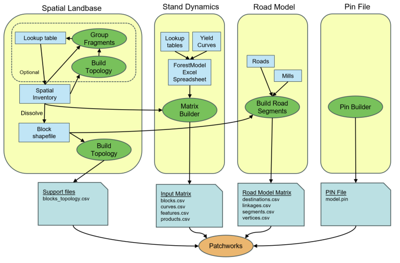
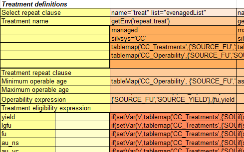
Patchworks uses the ForestModel language to describe stand dynamics. This language is complex and rich with features, providing power yet also making it a difficult system for casual users to master. One option that organizations can consider to make Patchworks model building easier for non-modelers is the use of model templates - an advanced and flexible data integration mechanism that is built into the baseline Patchworks product. Recently, Spatial Planning Systems worked with the Ontario Ministry of Natural Resources on a pilot project to explore using a model template for organizing forest management plan modeling data. In this article, we describe the implementation of this template.
Read More
Training
Self-paced training
Online self-paced training is available for the Patchworks modeling system. The training modules are included in the online documentation and are available to all Patchworks users. This self-paced training has had a recently been revamped to expand the material, provide better step-by-step illustrations, and highlight new features. This article describes the training that is available and what it covers.
Read More
Training
Sample data for the Quick Tour self-paced learning module
The C5 sample dataset is based on a portion of the Crowsnest Pass forest in western Alberta. The Patchworks sample model, which is derived from this dataset, incorporates a range of Patchworks features and serves as an excellent resource for demonstrations and learning. The self-paced learning sections in the Patchworks User Guide are based on this dataset. This article provides a link to download the version of this dataset required for the Quick Tour III exercise.
Read More
Model building
Model templates for Ontario
Patchworks uses the ForestModel language to describe stand dynamics. This language is complex and rich with features, providing power yet also making it a difficult system for casual users to master. One option that organizations can consider to make Patchworks model building easier for non-modelers is the use of model templates - an advanced and flexible data integration mechanism that is built into the baseline Patchworks product. Recently, Spatial Planning Systems worked with the Ontario Ministry of Natural Resources on a pilot project to explore using a model template for organizing forest management plan modeling data. In this article, we describe the implementation of this template.
Read More


